Illustration by Sarah Zeichner for Caltech Letters
The border between Iran and Afghanistan separates two vast deserts. To the west, the Dasht-e-Lut, or Plain of Emptiness. To the east, the Dasht-e-Margo, or Desert of Death. Between them lies the small town of Sefidabeh. On February 23rd, 1994, an earthquake shook this isolated settlement. Or more precisely, hit it dead on—the epicenter less than a mile from the town’s mosque. Over the next five days, four more large earthquakes struck the town. Six of the 200 inhabitants were killed and the town’s mud houses were flattened.
How, of all the places in this “barren, inhospitable and sparsely populated” desert, did the earthquakes manage to strike a town? The question cut through my early-morning daydream and dragged my attention back to the geology lecturer at the front of the hall. Until this point, geology had just been a required class on the way to my physics degree. Now, finding out the answer seemed like a worthwhile reason to keep my eyes open.
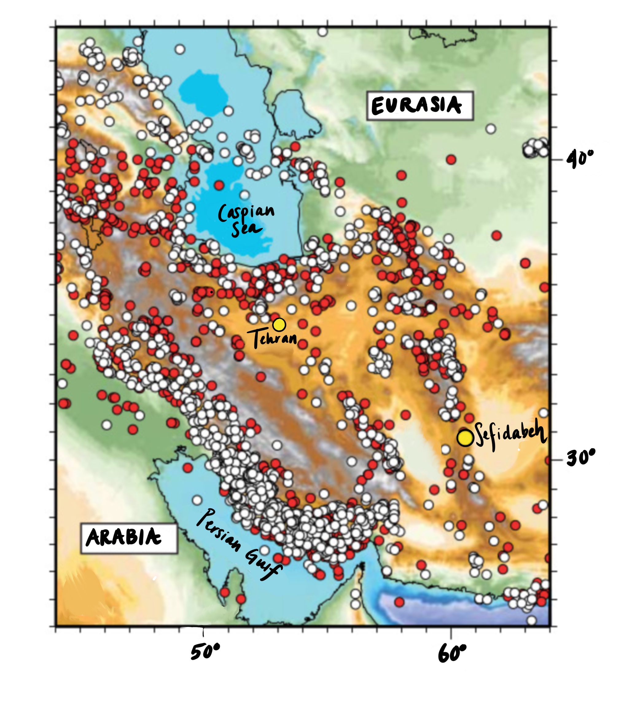
Earthquakes in Iran. White dots are earthquakes recorded by seismometers in the last 50 years, red dots are historical earthquakes reported over the last 1000 years. Earthquakes allow the rocks which make up Iran to move, as Iran is squashed by the Arabian plate moving towards Eurasia. Yellow dots show Sefidabeh and Tehran, cities whose location and fate are controlled by earthquakes.
Adapted from Jackson, 2006 by Sarah Zeichner
The key to Sefidabeh’s bad luck lies in the landscape. Tectonically, Iran acts as a crumple zone, caught between Arabia and Russia, as they move towards each other at an inch per year. Earth’s continents are a mash-up of old rocks, riddled with weaknesses. As Iran is squashed, rocks can suddenly slide over each other along these weaknesses, meaning that stresses that have built up over hundreds or thousands of years are released in seconds. This sliding is an earthquake. We call the area of weaknesses where earthquakes happen fault planes. If these fault planes reach the surface they might look like the stereotypical jagged line across the ground, but many of them end miles below our feet. If the fault plane doesn’t reach the surface, the rocks above will buckle, folding the ground above it into a hill.
The long, rounded hill to the west of Sefidabeh is one of these folds. The hill has grown upwards in successive earthquakes, about 2 feet every thousand years.
This hill, and the fault beneath it, explain how the earthquake hit Sefidabeh. But this is only part of the story. On its own, a hill a few hundred feet high wouldn’t make the hottest desert on Earth habitable. The real answer lies in the town’s name—Sefida (white) beh (water). As the west side of the fault slides upwards, it lifts up underground water, forming a line of springs along the base of the hill. The fault’s movement supplies Sefidabeh with fresh water, unlike the deserts around it. The source of the town’s existence was also the cause of its destruction.

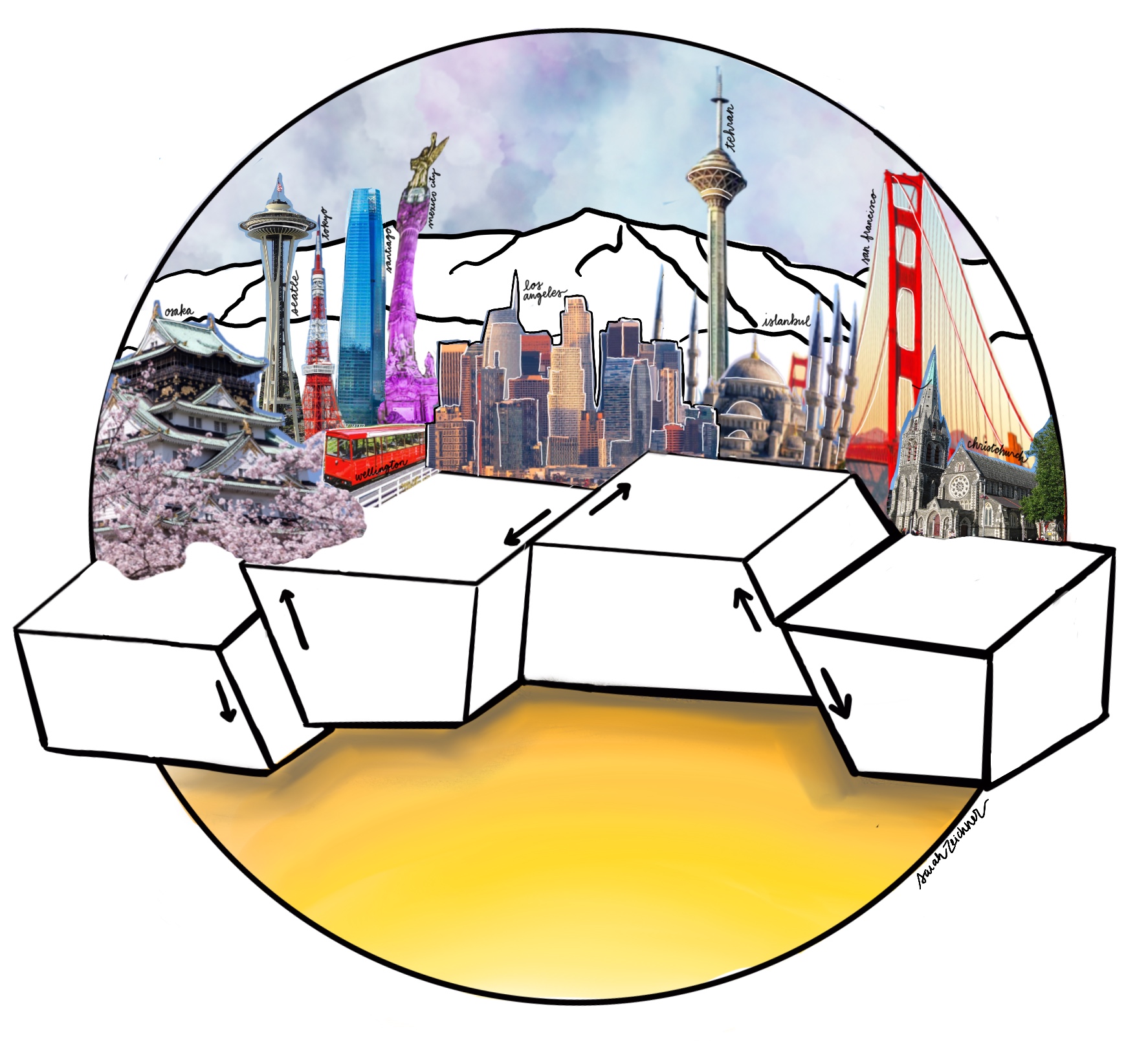
In an earthquake rocks slide past each other on fault planes. If the rocks move in the direction shown on the left, we call this a thrust fault. If the fault doesn't reach the surface (a blind thrust), the ground above it buckles forming a fold. A blind thrust fault formed the hill behind Sefidabeh, raising the water table and allowing springs to form in the desert. Similar faults provide water to towns across Iran. By recognising them in the landscape we can help local populations to be prepared.
Illustration by Sarah Zeichner for Caltech Letters
To me, Sefidabeh’s story is an example of the direct link between geology and people’s lives. By observing the earthquakes at Sefidabeh, and piecing together the story behind why they struck there, we could identify warning signs in the landscape around other towns, this time before an earthquake. The idea that the equations in my physics textbooks might actually help to save people’s lives gradually led me into geophysics.
Once I started looking, I found the role of earthquakes in the development of civilization hard to overstate. From the pass at Thermopylae, made infamous by the movie ‘300’, to the lines of Silk-Road cities along the edges of mountain ranges, faults have, and still do, control where we live. The reason we forget this is time. Considering that the time between earthquakes on a fault might be thousands of years, but our network of instruments to detect them is only 50 years old, it’s not surprising that we don’t always recognize the forces which shape the Earth. In my work, I combine whatever data I can get my hands on—measurements of the shaking from earthquakes, satellite images, precise GPS locations, rock chemistry—with physics, to put together a picture of how, and why, the continents we live on move and change shape.
Around the world, small towns, which began where a fault made springs in the desert, are becoming tomorrow’s megacities. In the time between earthquakes, a city’s population might have grown by tens of millions. It’s hardly surprising that new inhabitants are ill-prepared for the danger written in the landscape. A case in point is Tehran, the capital city of Iran. The ancient city of Rey (now a tiny section of Tehran’s southern suburbs) was centered around two hills above faults, much like the one in Sefidabeh. Unlike Sefidabeh, however, the faults providing water were not the main source of destructive earthquakes in Rey. The North Tehran Fault, which forms the steep slopes of the Alborz mountains to the north, presents a much greater hazard. Between 743 CE and 1177 CE, Rey was destroyed by at least four large earthquakes. The last major earthquake was in 1830. At the time, Tehran was still only a small town. Now, the urban area is home to over eight million people.
As well as increasing the number of people at risk from a nearby earthquake, Tehran’s rapid growth has made reading the landscape more difficult. By digging the foundations of skyscrapers, and laying concrete and tarmac, a new landscape is being built, obscuring many of the signs which normally help geologists to recognize earthquake-generating faults and work out how fast they’re moving.
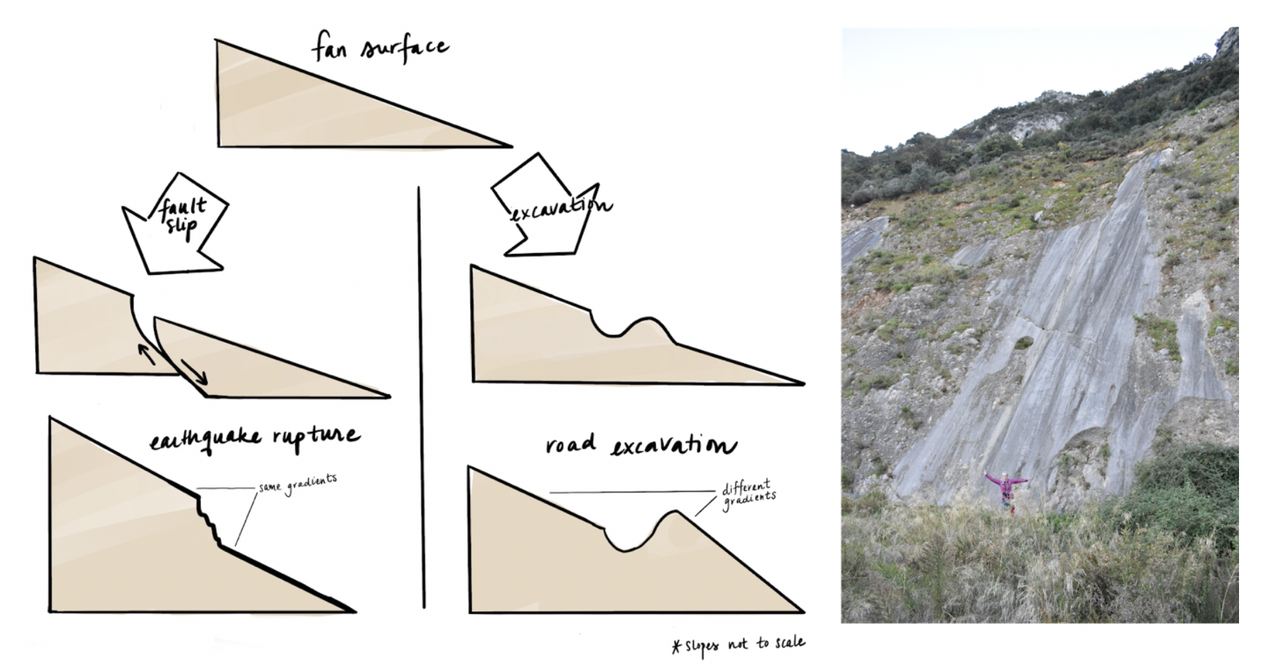
Even if earthquakes do reach the surface, telling the difference between human-caused features and earthquake ruptures can be difficult. One way to tell the difference is changes in gradient above and below the rupture. Construction work can make it even harder to read the signs of past earthquakes in the landscape. Sometimes though, building works can make faults much more obvious. An example is the Arkitsa fault in Greece (pictured right, author for scale). This fault plane was dug out to make a rubbish dump.
Left: Adapted from Copley et al. (2018) by Sarah Zeichner. Right: Ainsling O'Kane
Even when a fault is not hidden by development, a major challenge is how to piece together a record of earthquakes from long before modern measuring equipment existed. Iran is the perfect place for this enterprise, with a detailed historical record extending back several millennia, though using it brings a host of new analysis problems. Disentangling misspelt newspaper articles in Persian and Arabic and understanding which reported earthquakes were actually meteorites requires scholarship in the arts and humanities combined with scientific analysis. Evidence has even come from declassified spy plane photos. In Tehran, aerial photographs from 1956 show the traces of faults now obscured by the city’s development.
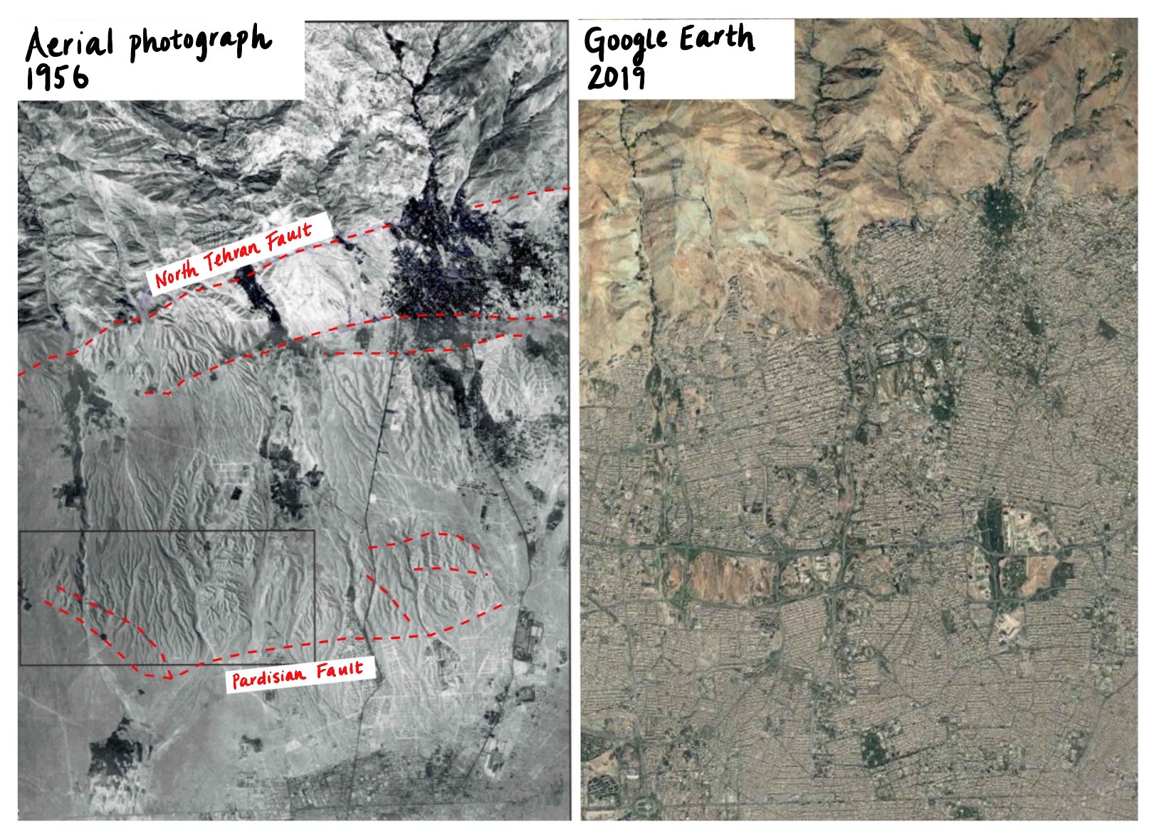
Tehran from the air, in 1956 (left) and 2019 (right). The city's northward expansion has obscured the faults which now run through its center (red dashed lines).
Left: Adapted from Talebian et al. (2016), Geophysical Journal International by Sara Zeichner. Right: Digital Globe for Google Earth
Generations of Iranian geologists have recognized earthquakes in Tehran as a danger:
Considering the continuous threat of earthquake hazard in Tehran and the suburbs, we should immediately prepare the necessary plans to mitigate the earthquake risk by utilizing the scientific and engineering techniques derived from earth sciences; we should do this before an earthquake strikes.
—Professor Setrāk Ābdāliān, 1951, Tehran (translated from Persian), quoted in Berberian & Yeats, 2017
However, the many human lifetimes between large earthquakes mean that this threat is not a top priority in most people’s (or the government’s) minds. I visited Tehran for a 10-day summer school in 2015, as part of the now discontinued Earthquakes without Frontiers program. Navigating the concrete sprawl in six-lane traffic beneath a layer of yellow smog, I could empathize with the inhabitants having other concerns. But the sight of the Milad hospital, perched on the crest of the hill above the Pardisan fault, was a constant reminder of the city’s vulnerability.
There are some positive signs for earthquake awareness. Iran has many brilliant earthquake scientists, some of whom I was meant to be teaching when I visited. As a first-year PhD student, however, I learned considerably more from them than they did from me (I quickly realized that one of my “students” had authored a key paper for my work). A particularly exciting initiative is Parsquake, which provides Persian-language information about how earthquakes work and how to prepare for them. Moreover, new satellites are now allowing us to detect subtle evidence of faults even where recent development has obscured the obvious signs.
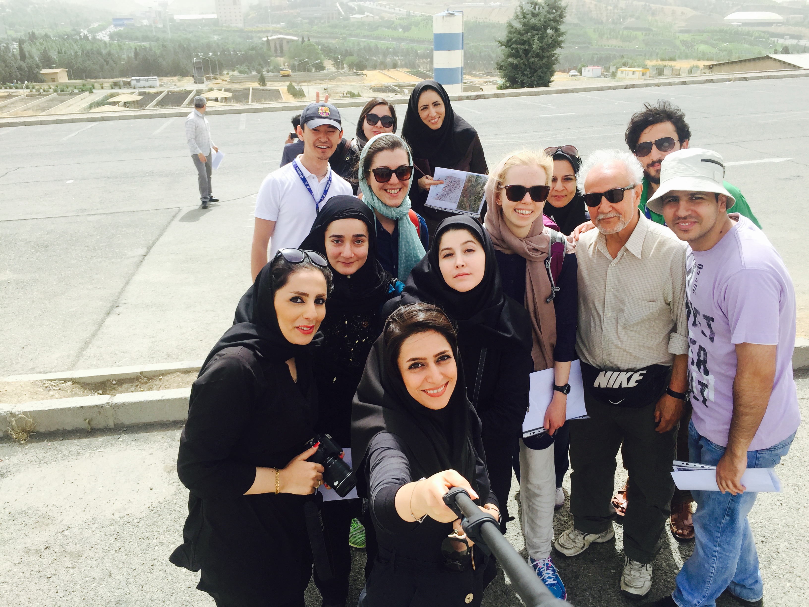
Iranian, Pakistani, Kazakh & British earthquake scientists stop to take a selfie on a field trip to look at Tehran’s active faults. The author is fifth from the right.
Faults obscured by rapid development pose a threat in cities around the world, not only in Iran. A little over a month before Sefidabeh was destroyed, one of the most expensive natural disasters in U.S. history occurred: the 1994 Northridge earthquake. This earthquake happened on the same type of blind thrust fault as those in Sefidabeh. The “ridge” in Northridge is the hill which is growing as this fault moves. In Los Angeles, like in Tehran, the city sprawl has made these faults harder to detect. At a time when divisions between Iran and the U.S. are widening, it’s worth remembering that the two countries have problems in common. The difference is that an earthquake in Iran is more likely to be paid for in lives than dollars.
Both countries, however, have a vested interest in understanding how earthquake-generating faults work. In my research I am constantly looking for the place on Earth which will give me the key insight into a particular problem, regardless of national boundaries. To solve the problems which the Earth poses we need science to build connections where politics does not.
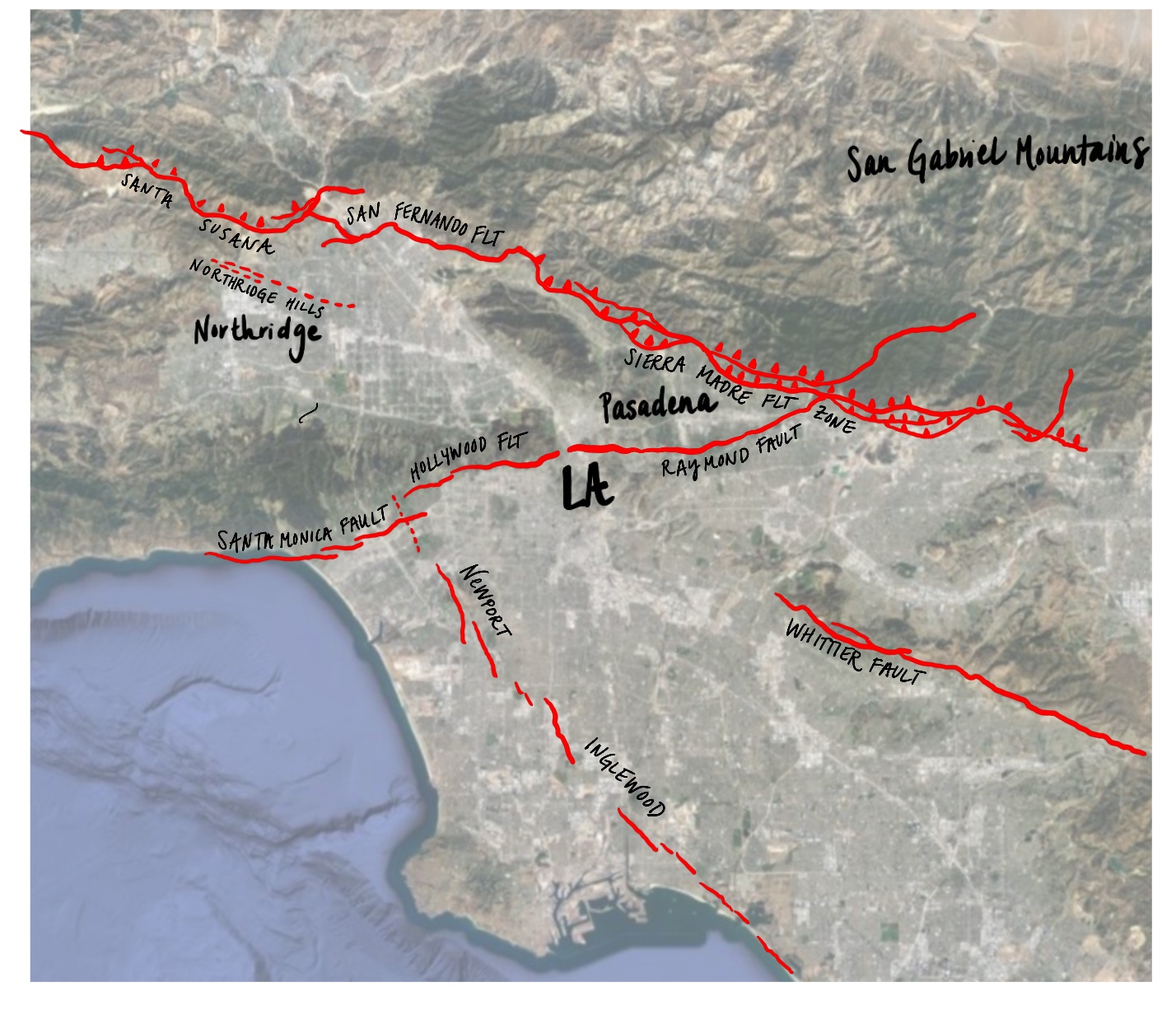
Some of the earthquake-generating faults which form the landscape around L.A. The fault that moved in the 1994 Northridge earthquake is dotted because the fault is a blind thrust, like Sefidabeh, so it doesn't reach the surface. Some faults, like the Sierra Madre fault—which forms the front of the San Gabriel mountains—are easy to see. In contrast, I live on top of the Raymond fault, in South Pasadena, California—all we know about this fault is that it has moved in an earthquake in the last half a million years.
Adapted from the active fault map of California by Sarah Zeichner
Earthquakes control the landscape, and the landscape controls where we live. This means learning to live with earthquakes. I was once told by an Italian architect that he had solved the Italian earthquake problem—the obvious solution was for everyone to leave Italy. Apart from the obvious drawback that many Italians might not want to relocate to earthquake-free Siberia, I think that running away from earthquakes is the wrong approach. Instead, we need to learn to read the signs in the landscape and prepare for the few minutes of violent shaking which, over millions of years, have also given us spectacular mountains and sources of water in the desert.
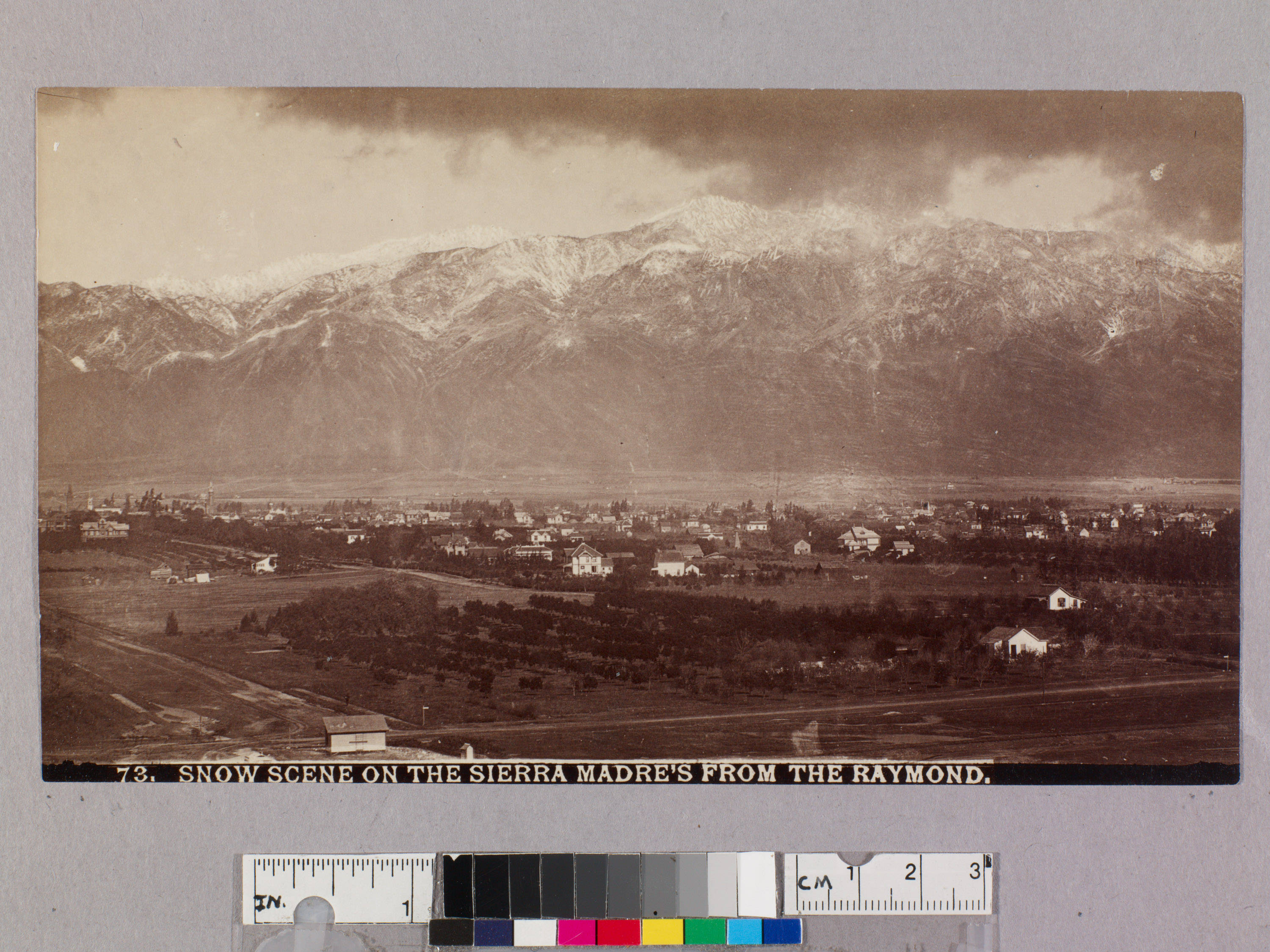
View of the San Gabriel mountain from the Raymond Hotel in South Pasadena, California, taken in about 1890. The Sierra Madre fault, which runs along the base of the mountains, is one of the easier faults to spot in L.A., but even here development has now obscured the evidence of past earthquakes.
Snow scene on the Sierra Madres from the Raymond. Circa 1890, The Huntington Library, San Marino, California

